
What is PAS128?
PAS 128 provides a robust methodology for delivering utility surveys in the UK. It focuses on levels of accuracy – referred to as Survey Category Types – that you can specify when requiring a PAS 128 compliant underground utility survey.
Survey category types
There are four Survey Category Types ranging from D - A:
-

PAS 128 Survey Category Type D
Desktop Utility Record Search. A thorough desktop search of all statutory asset owners to supply their record data. Some times referred to as a C2 Search.
-
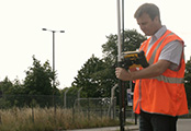
PAS 128 Survey Category Type C
Underground utility plotted from utility record data only, but with site reconnaissance to match utility record with physical utility street furniture as a best fit.
-
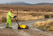
PAS 128 Survey Category Type B
An on-site utility mapping survey using multiple geophysical instruments. The output from this survey shall be each linear 5 metre section of utility depicted as a Quality Level (QL) 1-4 for horizontal and vertical detection accuracy.
-
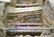
PAS 128 Survey Category Type A
Utility verified and positioned by physical identification. This may be by strategically positioned vacuum excavation, hand dug trail pitting or by visual inspection within a utility chamber.